[ad_1]
Did you ever wonder why there are weather gauges at Sky Harbor Airport?
Weldon B. Johnson/azcentral.com
Wochit
The display on your phone reads 120 degrees. The sign at the bank you just passed says it’s 121.
Yet you hear the “official” temperature for Phoenix at Sky Harbor Airport was only 119.
What gives?
Why do these readings differ? Isn’t the temperature the same all over town? Why is the official thermometer at the airport when no one lives there?
Aren’t there standards for this kind of thing?
Turns out there are standards for the placement of thermometers, rain gauges and other official weather-observation instruments. But there are many sources for temperature information and the quality of those sources can vary.
Why the airport?
The reason is both simple and practical, said Ken Waters, Warning Coordination Meteorologist with the National Weather Service in Phoenix.
“The reason for that is, most importantly, to get a really accurate observation for the airplanes coming in and taking off,” Waters said. “Their measurements have to be pretty accurate when you’re talking about things like visibility and cloud height. Airports have various restrictions where (planes) can’t take off if visibility or the base of clouds are below a certain level.”
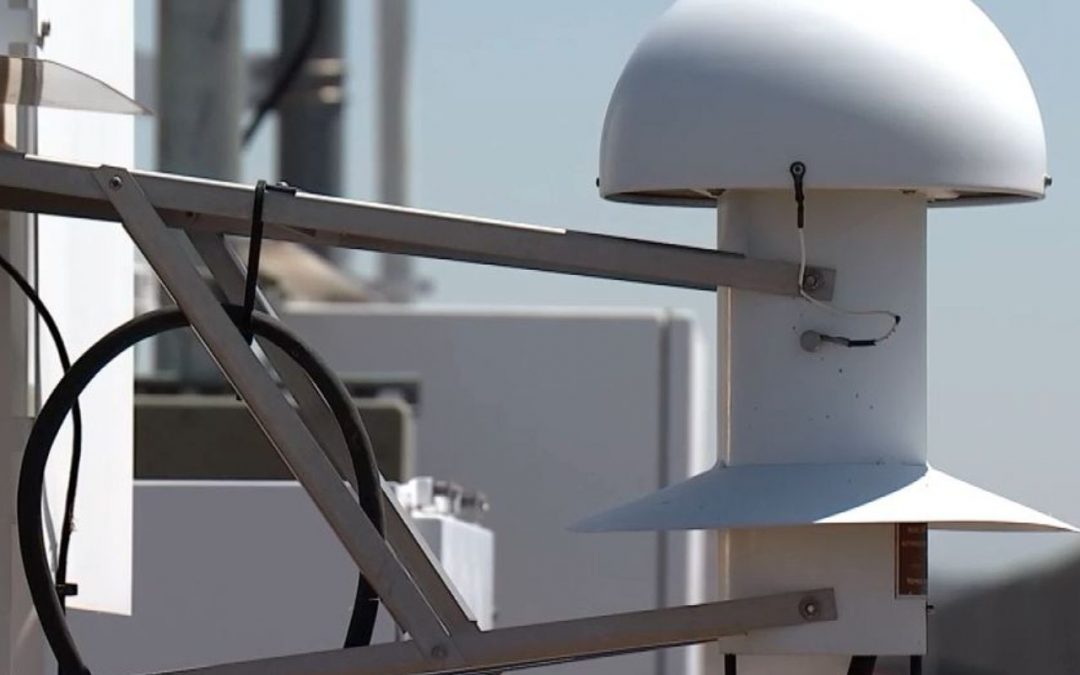
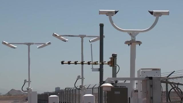
The instrument array at major airports such as Sky Harbor provides critical information such as air pressure, wind speed and direction, wind shear and lightning detection.
Some of these instruments help detect potentially dangerous weather phenomena such as microbursts (a column of sinking air within a thunderstorm). Microbursts can be deadly if they catch pilots landing an airplane by surprise.
So, you want those instruments as close to the runways as possible.
“If you have a sensor you’re using for planes to land and it’s a few miles away from the airport, that can be problematic,” Waters said.
Temperature isn’t usually the most critical factor for flight safety, but there are operating limits for aircraft. For example, last month’s extreme high temperatures caused the cancellation of dozens of flights at Sky Harbor. Air becomes less dense as it heats up, which makes it harder for planes to produce enough thrust to reach takeoff speeds. Pilots and airlines need to know when temperatures approach those safe operating limits.
A little history
The official thermometer for the city hasn’t always been at the airport.
Starting in 1895 when records were first kept, the official temperature was recorded in the city’s downtown. In 1954 meteorologists began making the observations at the airport.
The instruments have been moved a couple of times as the airport expanded. They have been in their current location near the southern edge of the airport since 2000, Waters said.
“I think it’s been in a couple of different locations at the airport,” he said. “We try not to move it too much. We want to maintain a pure period of record where it’s not moving around and potentially including any effects because of a different location.”
There are standards
The Weather Service strives for consistency not only at a particular location but within its network of stations throughout the country. As a result, there are standards for positioning instruments such as thermometers and rain gauges.
Official thermometers are placed at a height of 5 feet (give or take a foot) over unimproved ground.
The height standard is an attempt to measure air temperature at a level close to where people normally breathe. In locations where grass is common, thermometers are placed over grass. In Phoenix, the instruments are positioned over sandy, rocky soil.
Temperature sensors are placed in shade or, most often, in an enclosed structure that blocks sunlight but allows air to circulate. Placing the thermometer in direct sunlight could affect measurements. The enclosure also protects the thermometer from rain or snow.
The instruments are automated, transmitting data to their corresponding NWS office. (The Phoenix office is actually in Tempe, not at the airport.) Considering their importance to aviation, there are backup instruments at another location on the airport grounds.
Not the only game in town
Metro Phoenix covers a vast area and variations in terrain and other conditions cause different temperatures from city to city. In some cases, there are variations within a city.
While the Weather Service’s official observation site for Phoenix is at the airport, it’s not the only one. That’s why you can sometimes find significant variations in temperatures relatively close to one another.
For example, if you look at the current observations page on the National Weather Service’s Phoenix website, you can find significant differences within the city, not to mention the surrounding area. A station near the former Phoenix Greyhound Park consistently reports 10-15 degrees higher than Sky Harbor Airport. The station at South Mountain Park is usually cooler than the one at the airport.
Some services, such as cellphone apps, use weather networks other than the National Weather Service. Those commercial services may use different reporting stations for their information.
Some thermometers, such as the signs reporting temperatures at banks, other businesses or even in cars, report temperatures from on-site thermometers. Those thermometers can be warmer or cooler than the official site, depending on their surroundings.
“That’s one reason why, whenever you’re comparing one observation to another, you have to look at the siting,” Waters said. “The thermometer could be in direct sun or on top of an asphalt roof. That’s why we sometimes see some wacky observations.”
MORE AZCENTRAL ON SOCIAL: Facebook | Twitter | Instagram | Pinterest
Read or Share this story: http://azc.cc/2umvb0j
[ad_2]
Source link